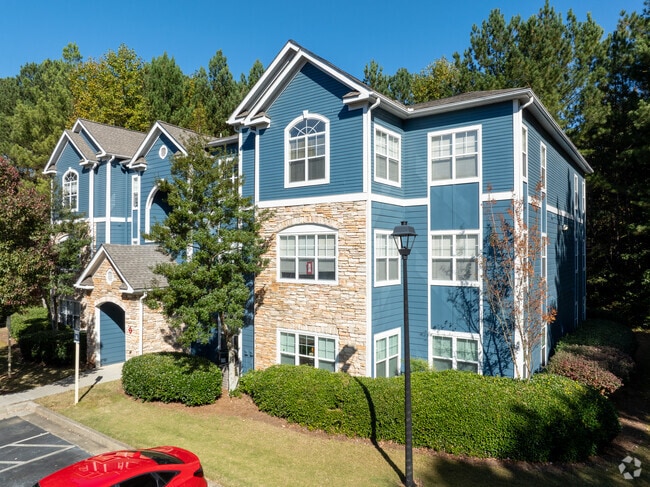
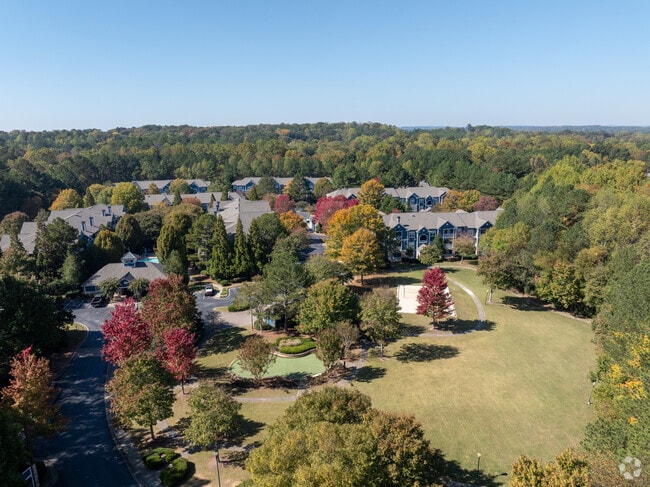
Property Record
1 Sycamore Ln, Woodstock, GA 30188

NEARBY LISTINGS FOR SALE OR LEASE
-
-
View all Woodstock listings for sale on LoopNet.com
Property Detail
1 Sycamore Ln
015N18-00000-164-000-0000
LL 1173,1204,1205; 15TH D
Apartment
Cherokee
A
Georgia
13057C0353E
21.69 AC
2025
Cherokee County
2025
Atlanta
090906
Atlanta-Sandy Springs-Roswell, GA
266,487 SF
DEMOGRAPHICS near 1 Sycamore Ln
1 Mile
3 Mile
5 Mile
2024 Total Population
9,121
67,444
166,656
2029 Population
10,289
74,278
180,780
Pop Growth 2024-2029
+ 12.81%
+ 10.13%
+ 8.47%
Average Age
41
40
40
2024 Total Households
3,584
25,208
60,573
HH Growth 2024-2029
+ 12.92%
+ 10.61%
+ 8.91%
Median Household Inc
$100,954
$102,554
$106,273
Avg Household Size
2.50
2.60
2.70
2024 Avg HH Vehicles
2.00
2.00
2.00
Median Home Value
$314,840
$357,635
$361,761
Median Year Built
2000
1994
1991
Nearby Places
Map Layers
Map Styles
 Street
 Aerial
- Restaurants
- Banks
- Shops
- Fitness
- Groceries
Nearby Properties
Address
Land Use
TOTAL SIZE
Lot Size
Zoning
Address
Land Use
TOTAL SIZE
Lot Size
Zoning
228,644 SF
7.88 AC
DT-CBD
Address
Land Use
TOTAL SIZE
Lot Size
Zoning
604,056 SF
25.03 AC
R-40
Address
Land Use
TOTAL SIZE
Lot Size
Zoning
181,704 SF
17.56 AC
DT-MRA
Address
Land Use
TOTAL SIZE
Lot Size
Zoning
128,196 SF
24.68 AC
R-4
Address
Land Use
TOTAL SIZE
Lot Size
Zoning
188,105 SF
25.86 AC
R-5
Address
Land Use
TOTAL SIZE
Lot Size
Zoning
330,192 SF
20.40 AC
GC
Address
Land Use
TOTAL SIZE
Lot Size
Zoning
328,203 SF
71 AC
R-40
Address
Land Use
TOTAL SIZE
Lot Size
Zoning
189,456 SF
28.35 AC
NC-TCT
Address
Land Use
TOTAL SIZE
Lot Size
Zoning
113,849 SF
7.46 AC
R-5
Address
Land Use
TOTAL SIZE
Lot Size
Zoning
186,426 SF
32.52 AC
NC-TCT
Address
Land Use
TOTAL SIZE
Lot Size
Zoning
161,310 SF
34.63 AC
R-40
Address
Land Use
TOTAL SIZE
Lot Size
Zoning
85,166 SF
3.41 AC
DT-CBD
Address
Land Use
TOTAL SIZE
Lot Size
Zoning
186,090 SF
30.08 AC
GC
Address
Land Use
TOTAL SIZE
Lot Size
Zoning
158,427 SF
11.17 AC
GC
Address
Land Use
TOTAL SIZE
Lot Size
Zoning
63,264 SF
8 AC
PUD
Address
Land Use
TOTAL SIZE
Lot Size
Zoning
156,752 SF
16.34 AC
NC-TCT
Address
Land Use
TOTAL SIZE
Lot Size
Zoning
89,552 SF
14.69 AC
DT-MR
Address
Land Use
TOTAL SIZE
Lot Size
Zoning
50,375 SF
5.77 AC
R-80
Address
Land Use
TOTAL SIZE
Lot Size
Zoning
88,795 SF
30.92 AC
DT-CI
Address
Land Use
TOTAL SIZE
Lot Size
Zoning
28,438 SF
GC
Address
Land Use
TOTAL SIZE
Lot Size
Zoning
72,376 SF
12.25 AC
GC
Address
Land Use
TOTAL SIZE
Lot Size
Zoning
135,538 SF
12.34 AC
DT-CMU
Address
Land Use
TOTAL SIZE
Lot Size
Zoning
56,141 SF
9.83 AC
GC
Address
Land Use
TOTAL SIZE
Lot Size
Zoning
158,889 SF
28.32 AC
GC
Address
Land Use
TOTAL SIZE
Lot Size
Zoning
83,076 SF
10.21 AC
GC
Address
Land Use
TOTAL SIZE
Lot Size
Zoning
36,188 SF
1.52 AC
DT-GC
Address
Land Use
TOTAL SIZE
Lot Size
Zoning
35,776 SF
1.50 AC
DT-CBD
Address
Land Use
TOTAL SIZE
Lot Size
Zoning
130,835 SF
20.09 AC
GC
Address
Land Use
TOTAL SIZE
Lot Size
Zoning
26,400 SF
1.10 AC
GC
The World's #1 Commercial Real Estate Marketplace
Connect with us
© 2025 CoStar Group
The information above has been obtained from sources believed reliable. While we do not doubt its accuracy we have not verified it and make no guarantee, warranty or representation about it. It is your responsibility to independently confirm its accuracy and completeness. Any projections, opinions, assumptions, or estimates used are for example only and do not represent the current or future performance of the property. The value of this transaction to you depends on tax and other factors which should be evaluated by your tax, financial, and legal advisors. You and your advisors should conduct a careful, independent investigation of the property to determine to your satisfaction the suitability of the property for your needs.